

Edit: Imagine Google streetview for OpenStreetMap, this is Panoramax. https://panoramax.fr/ https://wiki.openstreetmap.org/wiki/Panoramax
The free alternative to photo-mapping territories Panoramax is a digital resource for sharing and exploiting field photos. Anyone can take photographs of places visible from the public highway and contribute them to the Panoramax database. This data is then freely accessible and reusable by all.
During State of Panoramax panel at State of the Map France 2024, they announced a alpha/beta version for Android Panoramax application. Apk for android is available with the link and will be published on PlayStore and F-Droid. iOS users don’t worry a version will be available too.
You must log in or register to comment.
Care to share an explanation or link about what panoramix is?
Yes sorry, I add a link and an explanation in the post.
https://wiki.openstreetmap.org/wiki/Panoramax
Tldr: Google streetview for OpenStreetMap.
We had similar services before, but Mapillary was bought by Facebook, Kartaview/OpenStreetCam is slow as hell andeven the client’s source changed to proprietary at one point. Mapilio is similar but also closed source.
This finally aligns with the goals of the community, not another quick startup, you can install it on your server.
This is great! How does this system handle security/privacy concerns?
Google automatically blurs faces and license plates, and there are vulnerable and secure locations that are blurred by request, for example.
I would hate to see something like this misused by law enforcement or by violent radicals.
This also blurs faces and registration plates, e.g. see this random image
You can already check manually uploaded images on one of the servers:
In the docs they have a nice image showing how components work, the blur API does this work on the server:
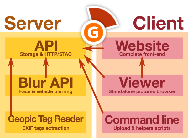
Documentation is here: https://panoramax.gitlab.io/gitlab-profile/
Full source code is on Gitlab: https://gitlab.com/panoramax
It’s developed in France, so GDPR applies to everything, EU rules are not a second thought. A main contributor and supporter is IGN (National Institute of Geographic and Forest Information) a French government institution. https://www.ign.fr/institut/identity-card